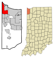
Hammond, Indiana
| City of Hammond, Indiana | |||
|---|---|---|---|
| — City — | |||
 |
|||
|
|||
 |
|||
| Coordinates: | |||
| Country | United States | ||
| State | Indiana | ||
| County | Lake | ||
| Incorporated | 1884 | ||
| Government | |||
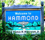
| - Mayor | Thomas McDermott, Jr. (D) | ||
| Area | |||
| - Total | 24.8 sq mi (64.3 km2) | ||
| - Land | 22.9 sq mi (59.3 km2) | ||
| - Water | 2.0 sq mi (5.1 km2) | ||
| Elevation | 577–610 ft (176–186 m) | ||
| Population (2006) | |||
| - Total | 79,985 | ||
| - Density | 3,221.7/sq mi (1,243.9/km2) | ||
| Time zone | CST (UTC-6) | ||
| - Summer (DST) | CDT (UTC-5) | ||
| Area code(s) | 219 | ||
| FIPS code | 18-31000[1] | ||
| GNIS feature ID | 0435658[2] | ||
| Website | www.gohammond.com | ||

Hammond (pronounced /ˈhæmənd/) is a city in Lake County, Indiana, United States. It is part of the Chicago metropolitan area. The population was 83,048 at the 2000 census, making it the 6th largest city in Indiana.[3]
Contents |
Geography
Hammond is located at (41.611185, -87.493080)[4].
According to the United States Census Bureau, the city has a total area of 24.8 square miles (64.3 km²), of which, 22.9 square miles (59.3 km²) of it is land and 2.0 square miles (5.1 km²) of it (7.85%) is water. The city's elevation above sea level is 176 m – 186 m (577 ft – 610 ft). The city sits within the boundaries of the former Lake Chicago. Most of the city is on sandy soil with a layer of black topsoil that varies from non-existent to several feet (a meter or more) thick. Much of the exposed sand has been removed for purposes such as industrial use to make concrete and glass.
Lakes and rivers
- Lake George
- Lake Michigan (partial)
- Oxbow Lake
- Wolf Lake (partial)
- Grand Calumet River (partial)
- Little Calumet River (partial)
Adjacent cities, towns and villages
- Burnham, Illinois
- Calumet City, Illinois
- Chicago, Illinois
- Lansing, Illinois
- Gary, Indiana
- Highland, Indiana
- East Chicago, Indiana
- Munster, Indiana
- Whiting, Indiana
Demographics
| Historical populations | |||
|---|---|---|---|
| Census | Pop. | %± | |
| 1880 | 699 |
|
|
| 1890 | 5,284 | 655.9% | |
| 1900 | 12,376 | 134.2% | |
| 1910 | 20,925 | 69.1% | |
| 1920 | 36,004 | 72.1% | |
| 1930 | 65,559 | 82.1% | |
| 1940 | 70,183 | 7.1% | |
| 1950 | 87,595 | 24.8% | |
| 1960 | 111,698 | 27.5% | |
| 1970 | 107,983 | −3.3% | |
| 1980 | 91,985 | −14.8% | |
| 1990 | 84,236 | −8.4% | |
| 2000 | 83,048 | −1.4% | |
As of the census[1] of 2000, there were 83,048 people, 32,026 households, and 20,880 families residing in the city. The population density was 3,630.0 people per square mile (1,401.4/km²). There were 34,139 housing units at an average density of 1,492.2/sq mi (576.1/km²). The racial makeup of the city was 72.35% White, 14.57% African American, 0.41% Native American, 0.46% Asian, 0.08% Pacific Islander, 9.32% from other races, and 2.81% from two or more races. Hispanic or Latino of any race were 21.04% of the population. Whites with no Hispanic or Latino ancestry were 62.40% of the population.
Ancestries: German (14.0%), Polish (12.3%), Irish (11.6%), English (4.7%), Slovak (3.9%), United States (3.9%).
In the city the population was spread out with 27.3% under the age of 18, 9.8% from 18 to 24, 30.1% from 25 to 44, 19.8% from 45 to 64, and 13.0% who were 65 years of age or older. The median age was 34 years. For every 100 females there were 95.3 males. For every 100 females age 18 and over, there were 92.2 males.
The median income for a household in the city was $35,528, and the median income for a family was $42,221. Males had a median income of $35,778 versus $25,180 for females. The per capita income for the city was $16,254. About 12.0% of families and 14.3% of the population were below the poverty line, including 19.7% of those under age 18 and 9.3% of those age 65 or over.
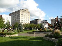
Cityscape
- Central Hammond
-
- Glendale Park
- Harrison Park
- Jacob's Square
- East Hammond
- Hessville
- North Hammond
-
- Robertsdale
- The Whiting post office (46394) serves not only the City of Whiting but also this adjacent Hammond neighborhood of Robertsdale, immediately to the west of Whiting. Addresses in this Hammond neighborhood show “Whiting, Indiana.” While not legally a part of the City of Whiting, locally the area has long been informally considered to be a culturally integrated part of Whiting. References to Whiting businesses or residents often include those technically from Hammond’s Robertsdale.[5][6][7]
- South Hammond
-
- Forest-Ivanhoe
- Indi-Illi Park
- Columbia Center
- Meadows
- Woodmar
Infrastructure
Transportation
Most of Hammond's streets are laid out in a grid pattern similar to Chicago's streets. While Madison Street in Chicago acts as the reference point for north-south street numbering the first "1" is removed; this makes what would be a five digit address number in Illinois into a four digit address number in Hammond. The state line is used as the reference point for east-west street numbering.
Other cities and towns in Northwest Indiana that use the Hammond numbering system are Whiting, Munster and Highland. Dyer also uses the Hammond numbering system but the first number removed from the north-south streets is a "2," as by that point the Illinois numbers across the state line start with the number 2 (Munster's Street numbers start with a "1" north of the Dyer line, making them 5 digits); and East Chicago uses the canal located in the middle of the city as the east-west reference point, while embodying Hammond's numbering system for the north-south streets.
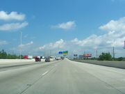
- I-90 - Indiana Toll Road, exits:
-
- Indianapolis Boulevard - U.S. Route 12/U.S. Route 20/U.S. Route 41
- Cline Avenue - Indiana State Route 912
- Calumet Avenue - U.S. Route 41
- I-80/94 - Borman Expressway, exits:
-
- Calumet Avenue (U.S. 41 North)
- Indianapolis Boulevard (U.S. 41 South, Indiana 152)
- Kennedy Avenue
- Cline Avenue (Indiana 912)
- The South Shore Electric Line, a Chicago to South Bend, Indiana commuter rail line, has a station on Hohman Avenue in Hammond. It is operated by NICTD.
- Amtrak, the national passenger rail system, provides twice-daily service in both directions, operating its Wolverine through the Hammond-Whiting stop between Chicago and Pontiac, Michigan, just north of Detroit. Baggage on Amtrak cannot be checked at this location; however, up to two suitcases in addition to any "personal items" such as briefcases, purses, laptop bags, and infant equipment are allowed on board as carry-ons.
- The nearest commercial airport is Gary/Chicago International Airport in Gary.
- Public Transportation is provided by the Northwest Indiana Regional Bus Authority, which assumed responsibility from the city's Hammond Transit System in 2010.[8] In addition, Pace routes 350 and 364 and Tri City Connection Route 12 from Gary, Indiana stop at Hammond's Dan Rabin Transit Plaza.
Medical centers and hospitals
The only hospital in Hammond is St. Margaret Mercy Healthcare Center, North campus. The hospital lies on Stateline Road, across the street from the Illinois city of Calumet City. The hospital was founded late in 1898 and was originally called St. Margaret Hospital. It merged with Our Lady Of Mercy Hospital in Dyer, Indiana, in the 1990s. The two hospitals became "campuses" of a new entity called Saint Margaret Mercy Medical Center and Hospital, part of the Sisters of St. Francis Health Services. It serves northwest Indiana and south suburban Chicago.
Utilities

- Electricity - Nearly all of the electricity used in Hammond is produced by Nipsco, a NiSource company.
- Natural gas - Nearly all of the natural gas used in Hammond is produced by Nipsco, a NiSource company.
- Water - Water service for nearly all consumers of water in the city is provided by the Hammond Water Department, a state owned utility that is operated by the civil city government.
History
The first permanent residents arrived around 1847 to settle on land between the Grand and Little Calumet Rivers, on the South end of Lake Michigan. Those first residents were German farmers newly arrived from Europe looking for land and opportunity. Before that time, the area was a crossroad for Indian tribes, explorers, stagecoach lines and supply lines to the West. Convenient location and abundant fresh water from Lake Michigan led to the beginning of Hammond's industrialization in 1869 with the George H. Hammond Company meat-packing plant following merchants and farmers to the area. Hammond was incorporated on April 21, 1884, and was named after the Detroit butcher.[9] Hammond is one of the oldest cities in Lake County, with Crown Point being the oldest, established in 1834.
On June 22, 1918, the Hammond circus train wreck occurred about 5.5 miles (8.9 km) east of the city, killing 86 and injuring 127 persons.
According to the 1960 U.S. Census Hammond's population reached a record high of 111,698 residents.[10]
Hammond is also the home of The First Baptist Church of Hammond, one of the nation's largest congregations.
The Flag of Hammond depicts the Grand Calumet River and the Little Calumet River.
Roby Tap was a legendary tavern within a suburb of the city that was finally torn down in 1999 to make room for an expansion of the Horseshoe Casino at the nearby marina. A popular watering hole for the workers at the nearby American Maize and Lever Brothers Soap factories as well as surrounding steel mills, it was founded in 1941. Longtime bartender Michael Smaluk and his wife his Margaret (who created the extremely popular Roby Tap Chili) ran the tavern until its eventual demolition in 1999.
The iconic 65,000 square feet (6,000 m2) Gothic Masonic Temple that was once the hub of social activity for many Hammond residents met the claw of an excavator on June 24, 2009, driven by Mayor Thomas McDermott, Jr., clearing the way for the new Hammond Urban Academy. The mammoth cornerstone to the ornately elegant three-story red brick building on Muenich Court was laid May 1, 1907, to great fanfare. Speaker for the day was none other than Charles Fairbanks, vice president under U.S. President Theodore Roosevelt. In 1921, the Masonic Building Association enhanced the building to the tune of $440,000. By the 1970s, its replacement cost was estimated at $4.8 million. In 2008, its estimated restoration would have topped $20 million.
Major Businesses

- Cargill
- Dietrich Industries (steel framing)
- Horseshoe Casino
- Lear Corporation (auto interiors)
- Unilever
- Jupiter Aluminum
- Tortilla Nuevo Leon (tortilla producer)
- Cabelas
- British Petroleum (partial)
- Indiana Harbor Belt Railroad
Education
Primary and secondary schools
Hammond is served by the School City of Hammond, a school corporation under Indiana state law that is independent of the civil city.
High schools
- Hammond High School
- Morton High School
- Area Career Center
Middle and high schools
- George Rogers Clark Middle/High School
- Donald E. Gavit Middle/High School
Middle schools
- Henry W. Eggers Middle School
- Scott Middle School
Primary schools
- Columbia Elementary School
- Edison Elementary School
- Benjamin Franklin Elementary School
- Warren G. Harding Elementary School
- Joseph Hess Elementary School
- Washington Irving Elementary School
- Thomas Jefferson Elementary School
- Kenwood Elementary School
- Lafayette Elementary School
- Lincoln Elementary School
- Maywood Elementary School
- Morton Elementary School
- Frank O'Bannon Elementary School
- Lew Wallace Elementary School
Privately owned and operated schools
- Bishop Noll Institute
- Bishop Noll Prep Academy (Junior High)
- City Baptist High School
- Chicago Baptist Academy
- Montessori Children's Schoolhouse
- St. Casimir
- St. Catherine of Siena
- St. John Bosco
- St. John the Baptist
Colleges and Universities
- Calumet College of St. Joseph- privately owned
- Purdue University Calumet - state owned
- Kaplan University - privately owned
- Indiana Dabney University - privately owned [11]
Public libraries
Hammond Public Library operates the Main Library, which includes the Suzanne G. Long Local History Room, at 564 State Street. In addition the system operates the E. B. Hayward Branch at 1212 172nd Street and the Howard Branch at 7047 Grand Avenue.[12]
City Government
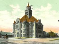
SW corner of Rimbach ST and Hohman AVE
(demolished)
Hammond is incorporated as a city under Indiana law. It therefore has a mayor and a nine member city council. Hammond's City Hall is located at 5925 Calumet Avenue.
The Hammond city council has meetings scheduled for the second and fourth Mondays of each month.
The city maintains a city court on the second floor of the City Hall,[13] exercising a limited jurisdiction within Lake County. The court handles not only local ordinance violations and certain minor criminal matters, but also a significant portion of the debt collection and eviction actions brought in Lake County.
- Councilmen at Large
- Robert A. Markovich
- Dan Spitale
- Kathleen Pucalik
- District Councilmen
- 1st District Mark Kalwinski
- 2nd District Alfonso L. Salinas
- 3rd District Anthony W. Higgs
- 4th District Kim Poland
- 5th District Daniel C. Repay
- 6th District Homero "Chico" Hinojosa
- City Officials
- Robert Lendi - City Controller
- James Callhan - Building Commissioner
- Brian Miller - Police Chief
- David Hamm - Fire Chief
The Mayor is Thomas McDermott Jr.. He is the son of former mayor Thomas McDermott Sr.
Past Mayors
- 1884 to 1888 Marcus Towle - Republican
- 1888 to 1893 Thomas Hammond - Democrat
- 1893 to 1894 Patrick Reilly - Democrat
- 1894 to 1898 Fred R. Mott - Republican
- 1898 to 1902 Patrick Reilly - Democrat
- 1902 to 1904 Armanis F. Knotts - Republican
- 1904 to 1911 Lawrence Becker - Democrat
- 1911 to 1918 John D. Smalley - Democrat
- 1918 to 1925 Daniel Brown - Republican
- 1925 to 1930 Adrian E. Tinkham - Republican
- 1930 to 1935 Charles O. Schonert - Republican
- 1935 to 1942 Frank Martin - Democrat
- 1942 to 1948 G. Bertram Smith - Democrat
- 1948 to 1956 Vernon C. Anderson - Republican
- 1956 to 1968 Edward Dowling - Democrat
- 1968 to 1976 Joseph Klen - Democrat
- 1976 to 1984 Edward J. Raskosky - Democrat
- 1984 to 1992 Thomas M. McDermott Sr. - Republican
- 1992 to 2004 Duane Dedelow, Jr - Republican
- 2004 to Date Thomas McDermott, Jr. - Democrat
Sports
- Past Teams
- Hammond Rollers, American Basketball Association team founded in 2006, and was sold to the owner of the Quad City Riverhawks the same year. The team is now known as the Sauk Valley Rollers of Rock Falls, Illinois.
- Hammond Ciesar All-Americans (1938–41) and Hammond Calumet Buccaneers (1948–49), professional basketball teams in the National Basketball League. Baseball Hall of Famer Lou Boudreau and legendary UCLA basketball coach John Wooden both played for the Ciesar All-Americans.
Hammond came in 2nd (against Taipei, Taiwan) in the 1972 Little League World Series.[14]
The Hammond Pros (1920–1924)
The Hammond Pros was one of the country's earliest professional football teams. When the American Professional Football League was formed in 1920, the Hammond Pros was a charter member, as it also was when the league changed its name to National Football League in 1922. However, four years later, when the NFL decided to reduce the number of teams, it did so by simply folding smaller franchises; the Hammond Pros (which never played a home game in Hammond) was moved to Akron, Ohio, and became the Akron Pros in 1925.
During the four years the Hammond Pros team was in existence, the NFL had nine African-American players, six of whom played for the Pros. The NFL's first African-American head coach was Hall-of-Famer coach Fritz Pollard of the Pros.
Notable natives and residents
- Robert K. Abbett - artist, illustrator
- Michael Badnarik - Libertarian Party 2004 presidential candidate
- Gerald R. Beaman - U.S. Navy admiral
- Dodie Bellamy - Author
- Stephan Bonnar - UFC Ultimate Fighter
- Jayne Boyd and Joan Boyd - original "Doublemint Twins" in ads for Doublemint gum
- Darrel Chaney - baseball player
- Denny Clanton - soccer player
- Irv Cross, NFL player and commentator
- Alberta Darling - Wisconsin state senator
- Danelle Folta - actress, model, Playboy April 1995 Playmate of the month
- Dory Funk - professional wrestler fighting under both his real name and as "The Outlaw"
- Terry Funk - professional wrestler and actor
- Khari Jones - football player in the Canadian Football League, television commentator
- Jeremy Jordan - actor, singer
- Joseph F. Meyer - horticulturist, herbalist, founder of the Indiana Botanic Gardens
- Fritz Pollard - born Chicago, first black NFL head coach for the now-defunct Hammond Pros
- Alvah C. Roebuck - born Lafayette, Indiana, founded Sears, Roebuck and Company
- Scott Sheldon - Major League Baseball player
- Jean Shepherd - born Chicago, raised in Hammond, TV and radio personality, best known as writer and narrator of the film A Christmas Story (1983)
- Bobby Skafish - Chicago radio personality
- Jimmy Valiant - professional wrestler
- Lois V. Vierk - music composer of the post-minimalist and totalist schools
- Jordan Schafer - baseball player
- Glenn Michael Souther - US Navy defector to the Soviet Union
- David Wilkerson - minister, evangelist and writer
Sister city
 Galaţi, Romania (since 1997)
References
- ↑ 1.0 1.1 "American FactFinder". United States Census Bureau. http://factfinder.census.gov. Retrieved 2008-01-31.
- ↑ "US Board on Geographic Names". United States Geological Survey. 2007-10-25. http://geonames.usgs.gov. Retrieved 2008-01-31.
- ↑ http://www.maps-n-stats.com/us_in_population.html Retrieved 2010-08-27.
- ↑ "US Gazetteer files: 2000 and 1990". United States Census Bureau. 2005-05-03. http://www.census.gov/geo/www/gazetteer/gazette.html. Retrieved 2008-01-31.
- ↑ Whiting History
- ↑ Whiting, Indiana - Chamber of Commerce
- ↑ Journey Through Calumet - Place
- ↑ "Transit System: Routes and Schedules". Northwest Indiana Regional Bus Authority. http://www.rba-nwi.org/fixedRoute.cfm. Retrieved 2010-07-05.
- ↑ "Profile for Hammond, Indiana". ePodunk. http://www.epodunk.com/cgi-bin/genInfo.php?locIndex=5404. Retrieved 2010-06-03.
- ↑ http://www.hammondindiana.com/history2.htm
- ↑ Indiana Dabney University
- ↑ "Library Information, Locations, Hours." Hammond Public Library. Retrieved on January 21, 2009.
- ↑ Courts - Lake County Bar Association - Indiana
- ↑ Little League World Series
External links
|
||||||||||||||||||||
|
||||||||||||||||||||
|
|||||||||||||||||||||||